About Castro Marim
The elegant outline of flamingos. The dusty gold of soft sand, the turquoise blue of warm waters. Vast ranges of hills covered in a bright carpet of wild flowers. The tranquil countryside along the banks of the Guadiana, lush with orchards and vegetable gardens. These are just a few facets of the municipality that stretches from the sea to the hinterland, with a river as its boundary.
History
The remains of the first settlements in the area date from the Neolithic period (approximately 5000 years BC). During this period Castro Marim was closer to the sea than it is now. According to geological research it consisted of an island surrounded by shallow waters.
For thousands of years Castro Marim was a port that offered shelter to the ships that sailed up the Guadiana river to collect the metals mined to the north in Alcoutim and Mertola. There is documentary evidence of the Phoenician and Roman presence in the area.
The Christian reconquest in 1242 was followed, in the second half of the 13th century, by a policy of repopulating and reinforcing local defences. This explains why King Dinis (1261-1325) made Castro Marim the headquarters of the Order of Christ, which had been established in 1319 to replace the Order of the Knights Templar.
Years later, the Order of Christ was transferred to Tomar, and this marked the beginning of a period of waning fortunes for the town. To reverse this pattern, in 1421 King Joao I granted Castro Marim the privilege of being a "sanctuary for fugitives".
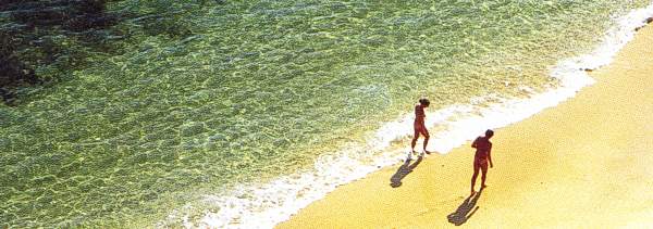
Beaches
Alagoa, Verde/Cabeco and Retur - Joined by a long, broad strip of sand surrounded by the green of pine woods, the three beaches are equipped with support facilities.
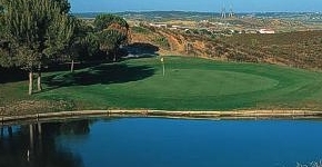
Golf
Castro Marim Golf
This is one of the newest courses in Portugal, having opened in 2000, in an area of the Algarve that until recently had no golfing infrastructures at all. The recently built course is part of a truly exceptional tourist development, designed to provide unforgettable moments of leisure. It has a very special setting in the peaceful atmosphere of the eastern Algarve.
Places of Interest
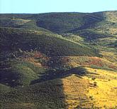
The Uplands (Serra)
Looking out from Castro Marim castle you see the sea on one side and on the other the rounded shapes of hills stretching away to the horizon. These are the uplands of the interior and they issue a silent challenge to everyone who is at home in wide, open spaces.
The roads that lead into the hills are punctuated by tiny hamlets of low white houses, surrounded by fields of crops, the cool expanse of the lakes formed by the Beliche and Odeleite dams, and the silhouette of ancient windmills perched on the hill tops.
Then there is the Guadiana river, winding its way through the empty spaces of the hinterland, on whose banks stands the picturesque village of Almada de Ouro, which takes its name from the gold that was once mined there.
Odeleite is a tiny oasis of verdure in a landscape dominated by the dusty browns of the local schist. Within the white walls of its church are some fine statues dating from the 16th and 17th centuries.
Visiting Castro Marim
Historical Centre
Linking the church, the castle and the fort, the streets of Castro Marim are lined with houses whose simplicity is typical of the architecture of the Algarve. White predominates, broken here and there by ochre and luminous blues. The bright borders painted on the facades bespeak a taste for geometrical patterns and floral motifs.
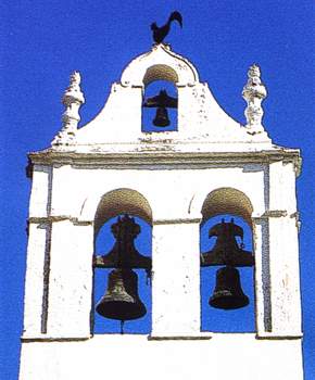
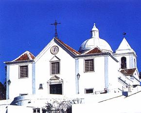
Main Church
The building dates from the 18th and 19th centuries and was originally a hermitage. The church suffered considerable damage in a fire in 1960. The church's most striking feature is its elegant bell tower surmounted by a false clerestory.
The main and side chapels are worth a visit for the statues of the arcanjo Sao Gabriel (archangel Gabriel) (16th century), which retains traces of polychrome decoration, Nossa Senhora da Encarnacao e dos Martires (Our Lady of the Incarnation and of the Martyrs) (16th century) and a finely proportioned Santa Luzia.
Misericordia Church
Unimpressive from the outside, this church houses a main altar with seven wooden panels dating from the 17th century and a collection of 18th century statues.
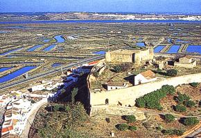
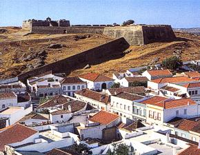
The Castle
The fortified wall that surrounded the medieval town on top of the hill has its origins in the 13th/14th centuries. At the time of the wars of the Restoration (1640-1668) the castle was adapted in accordance with the latest techniques of warfare, including the introduction of artillery.
The old castle stands on a broad open yard. Square shaped with circular towers at its corners and two gates, it is possibly Moorish in origin (10th to 13th centuries). The main gate bears an interesting design in relief, in the shape of a key.
The ramparts still enclose the former Misericordia, which has a Renaissance porch, and the ruins of buildings destroyed by the earthquake of 1755, including the main church (14th century) which was dedicated to Santiago (St. James).
Fort of Sao Sebastiao
This defensive structure was built in the 17th century and was part of a set of ramparts that surrounded the town, some parts of which are still visible between the houses.
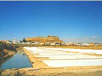
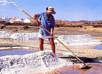
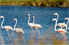
Salt Marsh Natural Reserve
Covering an area of 2,089 hectares, with wet areas of salt marsh, salt pans and creeks and dry areas of schist soils, red clay, arenite and sand, the reserve contains a wide variety of biotopes. It therefore offers a unique opportunity to observe the different ways in which plants and animals adapt to the natural environment.
For most visitors, the reserve's biggest attraction is undoubtedly the large number of birds - especially aquatic birds - that can be seen there. There are 153 species to spot, including storks, avocets, sand pipers, mallards and the ever popular flamingos.
Because the reserve is a permanent home to some species, a seasonal refuge for others and a migratory stopping off point for yet others, it offers ornithologists a constantly changing year round panoply of sights and sounds.
The great richness of its flora - 439 plant species in all - makes the reserve a paradise for those interested in botany. A visitors centre at Cerro da Rocha provides documentation and guides to itineraries.
Gallery